Arianarianvp
Mar 26, 2026, 11:09 AMI'm so done with tech. We all deserve to lose your jobs
I'm so done with tech. We all deserve to lose your jobs
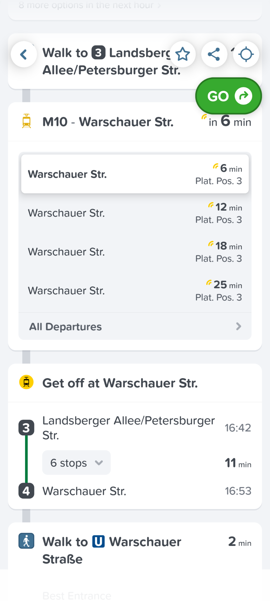
Google Maps also stopped showing connections that involve walks longer than 500 meters. It'll just be like "no its impossible to reach the other end of Berlin in half an hour by public transport. You need to change 6 times". Because it refuses to let me cross a bridge to another busstation because US brained people dont believe in legs.

@arianvp 😂

@arianvp oh is THAT what's up with it?! Ffs
@noodlemaz yes. And apple maps is even *worse*
 Mar 26, 2026, 10:22 PM
@arianvp @noodlemaz We’ve gone back to CityMapper because it became so bad.

@alper @arianvp @noodlemaz I check citymapper but also if possible a local app/website because I have now twice had citymapper suggest an impossible route because of a temporary closure - citymapper has links to descriptions of problems but they are not always integrated into the app, especially if they are short-term changes.
 Apr 11, 2026, 11:53 AM
@amyisard sometimes I wonder if it's possible to have a community crowdsourced open source Citymapper with public transport APIs hooked up, maybe built on CoMaps/OSM?
I love Citymapper and it's actually quite scarily accurate (if it says I'm late, I'm very much most likely late), but I always hesitate using maps apps in general due to privacy, but the problem is I'm a shut-in (by design of a tech nerd) and have been growing up so I never know how to go anywhere ever and have to resort to it anyway because CoMaps doesn't really do public transport in SG.

@jj Access to information makes this very very hard outside a big company, I've tried to get access to the realtime metro apis for Melbourne (to make a screen that told me when to leave lol) and never went through with it because of the shear amount of paperwork involved in getting a single JWT...
Apr 11, 2026, 3:42 PM@monoxane @jj @amyisard @arianvp @noodlemaz You don’t need real time. It’s not as if we have any real time data in Berlin for anything.
Also the algorithms by now are more than tractable and the volumes of data that you’re talking about quite modest.
Apr 11, 2026, 5:08 PM@alper @monoxane https://datamall.lta.gov.sg/content/datamall/en/dynamic-data.html
We do in SG :)
Pretty sure that's what Citymapper uses anyway, either this or some other API (never dug around enough to check yet), but point is they are available here.
 Apr 12, 2026, 2:38 PM

@alper
It looks like the app wants me to accept cookies by 334 partners. Do I have the wrong app?
Apr 12, 2026, 11:10 AM@mfriedenhagen 🤷🏻♂️ Nobody outside of Germany really cares about this stuff.
 Apr 11, 2026, 9:57 AM
@arianvp you just read my mind

@arianvp Just in case: Did you try changing the trip/route options? It's "least walking" by default.
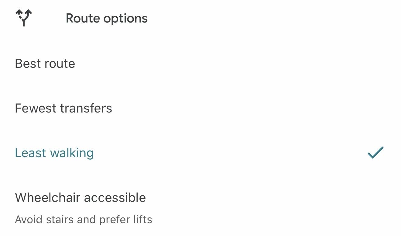


@arianvp I have noticed this as well, although I didn't realise it was because of the walking distance. So many times, I'm just confused on why it's not suggesting a route/connection that I KNOW is better...
 Apr 11, 2026, 11:20 AM
@ainmosni@social.ainmosni.eu @arianvp@functional.cafe I'm going to go out on a limb, and please don't confuse this as me defending this bullshit choice of theirs, but it might have something to do with how often walking that far can be impossible in the US. Not because of people's limitations, but because the public infrastructure to do so safely doesn't exist.
Obviously they should have people who know the area audit the routes their system is offering and adjust the defaults to reflect the local infrastructure. And please yell at them so they can fix it for your area. I'm just saying, this is very likely a systemic issue because of how car brained the people who build our infrastructure are, and how unsafe it is to walk in many parts of the US. And I say this as someone who was forced to use the broken infrastructure here for many years when I didn't have a car, where I was often walking along roads without sidewalks because there was no other route available to me or the next bus was an hour away, where my only other alternative was to pay for a fucking Lyft or Uber.
@deathkitten @arianvp All understandable reasons if I lived in the states... US developers thinking that nobody speaks a second language, walks, or lives in any way differently than they do in their silicon valley prison is quite annoying.

@deathkitten @ainmosni @arianvp Why do you need a sidewalk? Sincere question.
That's the beauty of walking. A sidewalk is not necessary.
(Other than highways, better to avoid highways.)
Walking is the freedom to go where you want to go without needing 'infrastructure'.
@penpencilbrush @deathkitten @arianvp To be fair, not having sidewalks in most urban environments (there's exceptions like Tokyo) is rough, as you definitely don't feel welcome as a pedestrian, and cars will treat you exactly like that. Sure, you can go off-road, but I don't always want to walk through the muck to get to places, especially if I want to arrive somewhere looking halfway decent.
@penpencilbrush @deathkitten @arianvp It's the same thing with not having good bicycle infra. Sure, bikes can share the road with cars, but many people will not feel safe and will opt to take the car. But have protected bike paths, and all of a sudden more people will opt to leave the car home.
And we have similar patterns with public transit. If the transit goes irregularly, gets stuck in traffic, and has stops in places that are not practical or make people feel vulnerable, people will keep on using cars.
@ainmosni @deathkitten @arianvp It never occurred to me. All my corporate life, I put on sneakers or very comfortable shoes with my suit and walked, under bridges, on bridges, grass, dirt, sidewalk, whatever.
I'm learning something every day. I love Mastodon.
With you on the public transportation and bike lanes. Build them (frequent, efficient and safe) and they will come.
@penpencilbrush @deathkitten @arianvp Yeah, fair, in the end it all comes down on the same thing, some people will walk/bike no matter what, but every time we get rid of a barrier, the group of pedestrians and cyclists will grow.
Like, I walk, cycle, or take transit everywhere, and because of the cities I've lived in, I never had the need to even get a drivers license. But when I visited North America, I mostly felt very dependent on friends to get around, as the non-car infrastructure was barren, and everything was built on a scale that assumed you would just drive.

@penpencilbrush @deathkitten @ainmosni @arianvp
I use a wheelchair and I like to go places too.

@deathkitten @ainmosni @arianvp
STROADS

@resuna @deathkitten @ainmosni @arianvp Ob- #NotJustBikes on cycling maps in the Netherlands/Amsterdam https://www.youtube.com/watch?v=csHdwHTteOw 🚴♂️ 🚴♀️

@ainmosni @arianvp Is that why it's impossible to find a route to a bar I regularly catch a tram to by just walking to the tram stop!?
It also explains why only some routes are asymmetric, the northward side of some stops is further away than the southward side of the stop so you can only connect one way?!
steve jobs, surrounded by fireworks. his mind blown.

@arianvp I stopped using Google maps something like two years ago. Now I mostly use CoMaps instead which uses OpenStreetMap data. It's not as complete as Google's such that searching for a local business has a better chance of failure than success. But, much like Google Maps, OpenStreetMap accepts user-submitted data. Unlike Google Maps, though, you're not providing a for-profit company with free labor, you're giving it to the community instead.

@StarkRG any way to get traffic information on co maps?
@davepotts Not that I'm aware of, it's not a feature that I need too often so I haven't really looked into it much. This is what I found with a quick search: https://wiki.openstreetmap.org/wiki/Traffic_data
There are other map apps that use OSM data, so maybe one of those has a traffic feature? It's going to really depend on your location, though.
It might be worth seeing what your local government provides of its own accord and then see if anyone's stuck that in an app form yet.

@StarkRG @davepotts
I mostly use CoMaps but I’ve been using the Here We Go app in preference to google maps for times when I need to take traffic into account. It also does Public Transport routes. Netherlands based company I think. Uses open street maps. Gets updates much more frequently than it used to.

@snaprails @StarkRG @davepotts It uses Here maps rather than OpenStreetMap.
@khleedril
You're right so it does 🙂
I was sure that it used to use OSM data but I see no mention of that now. Of course I might have confused it with one of the other slew of navigation maps that I've tried and then dropped - usually when they moved to an expensive subscription model.
@StarkRG @arianvp I also stopped using Google everything about two years ago; the specific enshittification of maps is that they are no longer reliable at finding the best routes: most times I sail right through dark red routes when all the lemmings following Maps go around the houses.
I *really* wish they hadn't gotten and then fucked up Waze.
 Apr 11, 2026, 2:29 PM
@StarkRG@myside-yourside.net @arianvp@functional.cafe Unless that for-profit company is called Microsoft (bing maps) or Apple (apple maps) which both uses OSM data for their mapping apps. But it's a fair trade, given they actually sink lots of money in OSM as a way to counter the Google machine. Plus it's good to say "but actually the data is used in X and Y.
 Apr 11, 2026, 12:23 PM
@arianvp on the off-chance you haven't seen this, you may want to have a look at something like @transitous
For example, here is Berlin Bösebrücke to Wansee
https://api.transitous.org/?time=2026-04-11T12%3A21%3A00.000Z&fromPlace=52.5545508%2C13.4014075&toPlace=52.4211482%2C13.1589374&withFares=true&fastestDirectFactor=1.5&joinInterlinedLegs=false&maxMatchingDistance=250&fromName=B%C3%B6sebr%C3%BCcke&toName=Wannsee

@arianvp algorithms never walk anywhere, never use public transport, have no idea what they talk about. They just follow the mental model the programmer (human or AI, does not matter) used as a reference.
For the longest time I wished Google maps would understand that some destinations are extended objects, like, it doesn't matter which side of this area you enter because you're there once you get there. But it only knew about points.
Now they seem to have added extended targets, but they still only have one "point" that is the target, so no matter where in the target you're headed to ut always sends you to the same gate or entrance. Which is worse because now you can't override them.
 Apr 11, 2026, 7:00 PM
It will do that. I deliberately set a landmark at the east most parking entrance of the building. It still navigated me to the southern entrance, because that is apparently where it believes there is an entrance to that block. And then its plotted route included internal directions inside the parking floor to the eastern entrance.

@arianvp Just use a map, not a shopping guide.

@arianvp Apple Maps has done this thing for a while where, if you set the default mode of transport to ‘walking’, over a certain distance (5km I think) it’ll ignore you and assume you want to drive.
I sort of understand the decision to ignore the default: it’s probably true that I’m not going to walk 10km for a random errand. (If I am going to walk that far it’s an intentional choice.) But you can’t configure the fallback. Even if somewhere is too far to conveniently walk, that doesn’t mean driving is an option.
 Apr 11, 2026, 2:47 PM
Because I had most recently used it for crossing the city, google maps recently offerred me walking directions from Boston to Montreal. (I'm a fast walker but no.)

@arianvp StopTheMadness has the ability to disable translated titles on YouTube.

@arianvp one time, in Brussels, I asked the front desk of the hotel if they could give me directions somewhere on a very nice day. “I can call a taxi for you…” “But it’s only 2 or 3 kilometers?” “Well, Americans don’t like walking!”

@arianvp
Google Maps managed to lose a river in Ireland. The last section of one, anyway.
Go past the western edge of County Dublin until you find the Intel Ireland campus. Zoom in and follow the river (Rye Water) that runs behind it, until it reaches an aqueduct.
In reality, the aqueduct carries a canal/rail line high above the river valley, and the Rye eventually reaches the Liffey. Google Maps shows the river flowing directly into the canal, on a neat 90 degree T junction, with no spills.
@arianvp
Between the the aqueduct and the Rye/Liffey confluence, there's a river-shaped gap in Google Maps. An unexplained meandering green area of undeveloped land cuts through a residential area, where every housing estate has a river-themed place name. It's almost like someone is trying to drop hints that a river is very close by.
I tried fixing it in GMaps more than 10 years ago but it doesn't allow rivers to be edited.
Every other map seems to have the full Rye Water present and correct.
 Apr 12, 2026, 10:23 AM
@arianvp other maps solutions are available. Comaps via Fdroid for example.

@arianvp if you want to get in close contact to an american police officer, try to cross a street in Texas by yourself.
"Are you crazy? Why you don't use your car? Hands on the wall!"
https://www.auto-motor-und-sport.de/verkehr/fussgaenger-gesetz-new-york-erlaubt-jaywalking/

@arianvp Google Maps has the bug of you can only specify one type of travel. The trip has to be all car, all bus, or all walking, no combining two or more into a single trip. You have to do two different trip searches if you need to walk between bus stops to change bus lines. I had it tell me that I need to take a long (45 minute) looping bus ride to get somewhere that I could have walked to in 5-10 minutes had I known to do that for the last leg of the trip.