Login
You're viewing the adforward.org public feed.
  • Nov 6, 2026, 2:44 PM

    Much of the data is just wrong, clearly misinterpreting the relative independence of different places. Probably really quite a lot of it, since the spot-checks I've been able to do at a glance have found a bunch of issues.

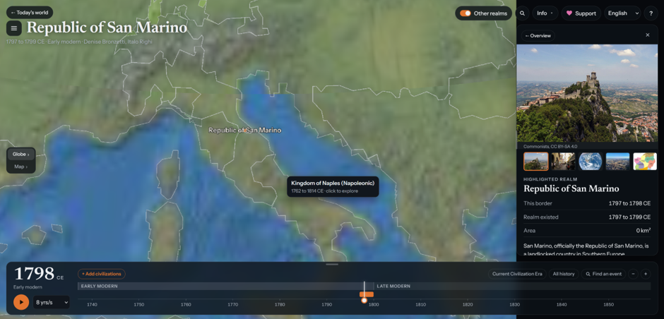
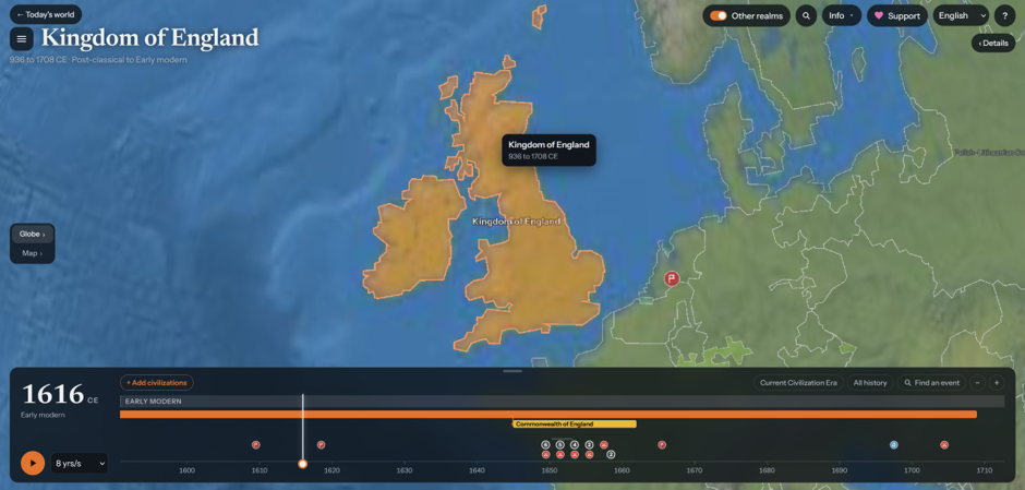
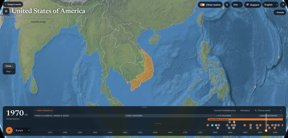
    Here we have Czechoslovakia being treated as part of the USSR after the Prague Spring (no, still in the Warsaw Pact), South Vietnam in 1970 as a direct US territory (nope!), Scotland in 1616 labelled as England, and San Marino apparently losing independence in 1799.
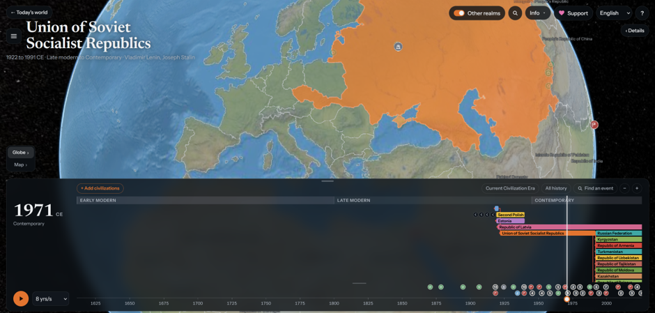
    Terra tempora map showing the USSR in 1971 including Czechoslovakia.
    Terra tempora map showing south Vietnam in 1970 as an American possession.
    Terra tempora map showing the Republic of San Marino as only existing from 1797 to 1799, which would probably be news to the Sammarinese who are decidedly independent as of the present day.
    Terra tempora map showing Britain in 1616 with Scotland marked as part of the Kingdom of England, something it decidedly was not – nor was it the same country at all officially until the Act of Union most of a century later.
    💬 1🔄 22⭐ 33

Replies

  • Nov 6, 2026, 2:45 PM

    I think this is an inherent issue - I could keep generating casual spot-check problems like that for weeks if I had the time to do so, the scope of human history is large enough that this sort of auto-processing will always produce these levels of errors. You do need historians to do history!

    I also think there are some even more fundamental issues with the data-vis, though - ways that this events-and-civilisations model distorts our understanding of the past more than supporting it.

    💬 1🔄 12⭐ 41
  • Nov 6, 2026, 2:46 PM

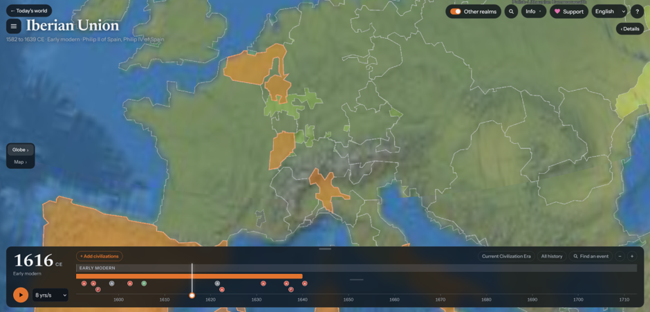
    First, map gaps. Some of these are just nonsensical, like the example below where some parts of the 1616 Holy Roman Empire are apparently non-entities.

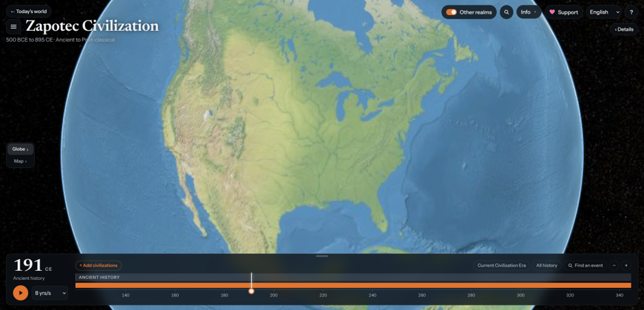
    Some are more troubling though. Oceania is a blank space before British colonisation in Australia: the pre-colonial histories of Australia and Aotearoa are relegated to "non-civilisation", erased entirely. Even some known cultures like the Hopewell are absent: the computer is unthinkingly replicating the full colonial model of who gets seen.

    Terra tempora map showing Europe 1616, with the southern Low countries labelled as part of the “Iberian Union” but also with several random holes in the Holy Roman Empire.
    Terra tempora map showing North America, 191CE. The map is empty. This should be the height of the Hopewell culture, which is not deemed sufficient to be included as a “civilisation” here.
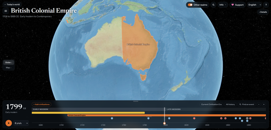
    Australia 1799, with the British Colonial Empire occupying a near eastern half of it and the western half and New Zealan simply blank. This erasure of cultures that did not fit a state model was really popular in the colonial era for obvious reasons.
    💬 1🔄 16⭐ 37
  • Nov 6, 2026, 2:47 PM

    The next problem to consider is what creates a 'top level' unit. "Independence?" What does that even mean? Many historical leaders were concerned with stability and extent of power more than "independence" in a modern-state sense.

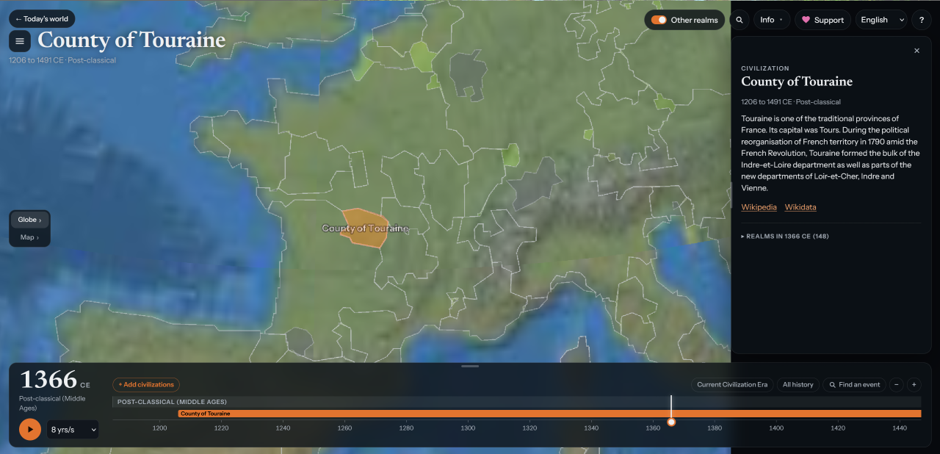
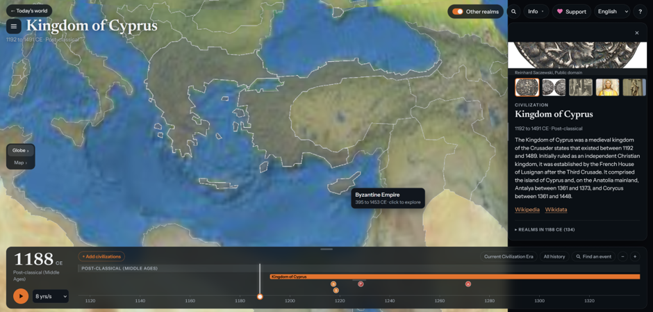
    The approach here is totally confused. 1366 Touraine here is a "civilisation" despite being a (misplaced) county: Isaac Komnenos' independent Cyprus in 1188 is Byzantine which would have been news to the Byzantines who had recently lost a fleet trying to recapture it.

    Touraine 1366. It appears to be in the wrong place, but also, it’s a county, why is it labelled as a separate *civilisation*?
    Cyprus 1188 shown as part of the Byzantine Empire. Isaac Komnenos had ruled it independently since 1185.
    💬 1🔄 4⭐ 22
  • Nov 6, 2026, 2:47 PM

    Even modern political structures don't work well on border maps, as we saw earlier with the Czechoslovakia problem. Premodern ones work far, far worse. English kings held land in France at times *as vassals of the French king with respect to that land*, so is that English land or French? Map-painting also obscures many ways of life: giant blobs for nomadic peoples with labels like "Kipchak confederation" do no justice to the actual ways that people interacted with or controlled territory.

    💬 1🔄 7⭐ 32
  • Nov 6, 2026, 2:47 PM

    Or take the Mkhargrdzeli family - whose domains are just treated as part of the Kingdom of Georgia, and it's true that they were officials at the Georgian court but they also have inscriptions proclaiming themselves as kings despite being vassals of the Georgian monarchs, because that was a culture & period where kingship and "independence" did not need to be aligned (actually quite common).

    💬 1🔄 1⭐ 20
  • Nov 6, 2026, 2:48 PM

    So why does all this end up being the case? I think firstly it derives from wanting to flatten history into something that's just too simplified. Categories like civilisations and empires and realms often do a lot of historiographical work, and visualisations like this present them as consistently *the same type* of entity, even if some are city-state collections and not unified polities at all. There is no one model of what a "civilisation" is and political power overlaps a lot in reality.

    💬 1🔄 7⭐ 26
  • Nov 6, 2026, 2:48 PM

    There's an underlying problem with a data-scraping/AI approach to this though which is that we end up reflecting the data quantity biases in Wikipedia (largely written by western Europeans/N Americans & wildly skewed in its topic matter) and, where AI is involved, derived from general pop historiography because a large language model's weights will not default to more complex representations than the average, and the average by statistical weight is rooted in very old fashioned histories.

    💬 1🔄 11⭐ 27
  • Nov 6, 2026, 2:48 PM

    I don't think that the author of this tool intended it to be what it is - but what I see in it is mostly a replicator that hardens existing biases in its sources and presents them as data-visualised fact. When it comes to things like erasing the complexity of recent political arrangements that affect people today, or wiping out indigenous histories in colonised parts of the world, then I think there is a real ethical problem with that as a way of approaching how we view and explore the past.

    💬 1🔄 8⭐ 33
  • Nov 6, 2026, 2:49 PM

    Whilst I'm very far from the end of academia that thinks academia has all the answers, in this case we do have quite a few of them. First, tools like this need to come with a lot more clarity in what they do *and don't* show, making clear their limitations to public users. Engage with scholarship on what you're trying to do: good historical data-vis isn't a few days' project with Claude, it's real work. Finally, talk to a historian, or if you want to do global history, quite a lot of historians.

    💬 1🔄 4⭐ 27
  • Nov 6, 2026, 2:49 PM

    Historical data isn't like scientific data, it doesn't come polished. Everything is skewed and incomplete, and we need data visualisations that help people understand that rather than pretending a sense of completeness that isn't there. This sort of tool doesn't make those recognitions and doesn't appear to have had any significant spot checks or discussions with experts, and the result is something that is frequently a misleading mess at best and runs into real ethics questions at worst.

    💬 1🔄 15⭐ 31
  • Nov 6, 2026, 2:52 PM

    This isn't the first data-scrape/AI history attempt I've seen and I'm sure there'll be more. If this sounds negative, it's not to dunk on this guy in particular: rather, it's because I really think it's important for you, dear reader, to carefully think about these problems. We're going to face more of them in public history - and it's going to exacerbate existing problems with how we ensure good quality information gets a hearing. I hope we can learn to do better.

    Here endeth the thread.

    💬 0🔄 10⭐ 34